Flash Flood Risk Rises Across Northeast Corridor With Rounds Of Heavy Rain Coming
The Northeast is preparing for a dramatic weather shift following days of heat that broke records, as bouts of heavy rain threaten to cause deadly flash flooding in major towns and traffic routes.
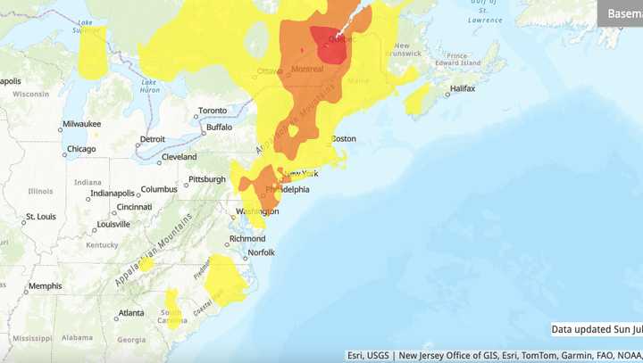
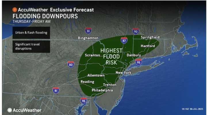
Locations most vulnerable to flash flooding Thursday, July 31, to the morning of Friday, August 1.
Rainfall will be heavy at times from Thursday, July 31, to Friday, August 1.
Communities west of Boston are at increased danger of flash flooding from Philadelphia and New York City due to a surge of drenching rainfall that is expected to move over the Northeast on Thursday, July 31, and Friday.
The region could see 2 to 4 inches of rain, with localized totals perhaps as high as 8 inches in continuous downpours, according to AccuWeather meteorologists.
Particularly in regions with hilly terrain, creeks, streams, and other flood-prone places, heavy rains can cause flash floods in a matter of minutes, AccuWeather Chief Meteorologist Jonathan Porter cautioned. “Even if the water seems to be just a few inches deep, drivers should never try to travel down a flooded road.
“It is impossible to determine the depth of the water, its speed, or whether the bridge or road beneath it has been damaged or washed out. The majority of fatalities from flash flooding are avoidable and involve vehicles. Avoid endangering yourself, your passengers, onlookers, or emergency personnel.
Everyone should pay close attention to flash flood warnings and watches, especially after dark. Make sure you can get flash flood alerts in a variety of ways.
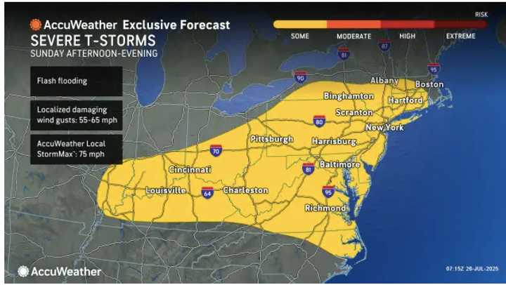
The I-95 corridor is predicted to get the most rainfall, with effects extending into the I-80 and I-81 corridors.
The potential of unexpected flooding in low-lying and urban areas might be increased by thunderstorms that could reach as far south as Washington, DC, and the Carolinas.
Major airports in Boston and New York City may face delays, and commuters should brace themselves for decreased visibility and potential travel disruptions during the Thursday and Friday morning and evening rush hours.
However, relief is imminent as the recent stretch of intense summer heat is expected to cease when a wave of cooler, less humid air moves into the Northeast and Great Lakes region following the storms.
This weekend, lows will be in the 40s in the mountains and the 60s in several communities along the I-95 corridor. Over the weekend, temperatures over the coolest alpine locations might even reach the 30s in a few places.
Residents are advised to take precautions in flood-prone regions and remain vigilant for flash flood warnings until then.
For updates, return to Daily Voice.