Flash Flood Watch In Effect Across NJ, PA As Storms Threaten Roads, Power: NWS
A powerful round of thunderstorms is expected to hit New Jersey and eastern Pennsylvania beginning Monday afternoon, July 14, with the National Weather Service warning of flash flooding, possible power outages, and dangerous driving conditions.
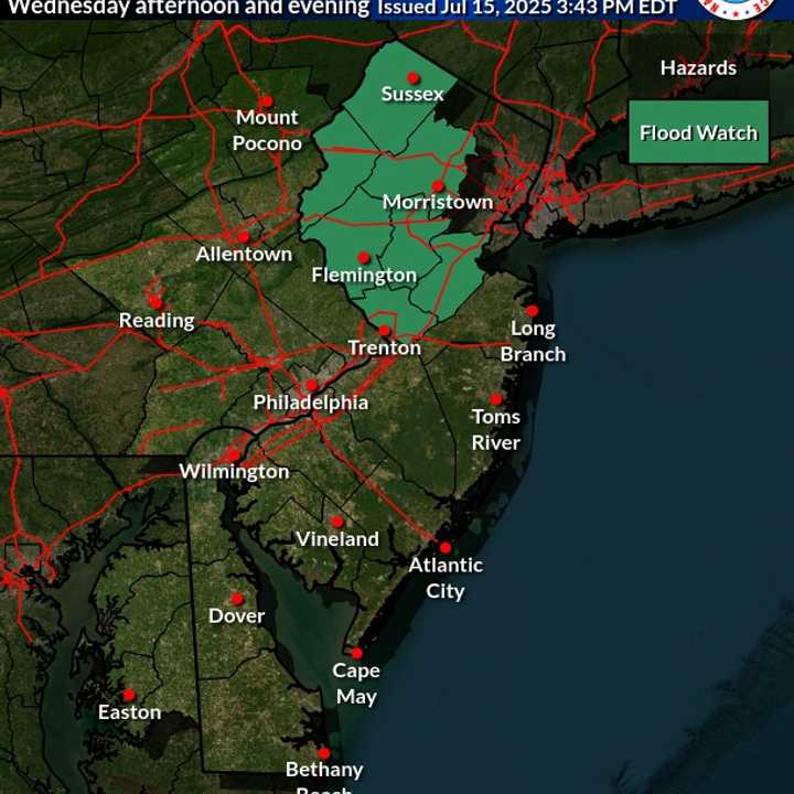
Flood watch Monday, July 14.
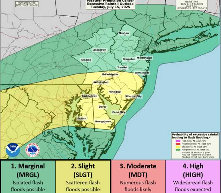
The NWS in Mount Holly issued a Flood Watch that remains in effect through 2 a.m. Tuesday for large parts of the region. Some areas could see rainfall rates exceeding two inches per hour, with total accumulation of up to five inches in spots. Another round of storms is likely Tuesday afternoon, adding to the risk.
According to forecasters, the greatest threat lies in a “Moderate Risk” zone stretching across the Philadelphia metro area, central and southern New Jersey, and parts of southeastern Pennsylvania. Trenton, Camden, Vineland, and Atlantic City are all in the crosshairs.
“Showers and scattered thunderstorms will develop this afternoon and continue into tonight,” the NWS said in its early morning update. “Localized rainfall amounts of 3 to 5 inches are possible.” That much rain, falling in a short period of time, could flood streets, overrun drainage systems, and turn creeks and small streams into rivers.
But not everyone will be hit equally.
North Jersey May Be Spared The Worst
While the entire region could see some storm activity, northern New Jersey, including Bergen, Passaic, Sussex, and Morris counties, is expected to see far less impact. These counties fall just outside the Moderate Risk zone and are instead listed under a “Marginal Risk” area, where rain totals should be lower and severe weather less likely.
Forecasts show that northern New Jersey could still get passing storms, occasional downpours, and brief gusty winds, but widespread flooding or wind damage is not expected. Commuters may experience minor street flooding in areas with poor drainage, but overall, the threat is significantly lower than in the central and southern parts of the state.
Even so, the NWS warned that “additional rounds of showers and storms are forecast through the end of the week,” meaning the unsettled weather could linger into Wednesday and Thursday.
Counties Under Watch
The Flash Flood Watch covers much of central and southern New Jersey, including Mercer, Middlesex, Monmouth, Ocean, Burlington, Camden, Gloucester, Atlantic, and Cape May counties, as well as southeastern Pennsylvania counties like Philadelphia, Montgomery, Delaware, Bucks, Chester, and Berks.
Meanwhile, counties like Bergen, Morris, Sussex, Passaic, Warren, and Hunterdon are not under a Flood Watch but should still keep an eye on changing conditions, especially if traveling south.
What Comes Next
Storms are expected to continue off and on through Monday night. The heaviest rainfall is likely between 6 p.m. and midnight, forecasters said. Additional storms may develop again on Tuesday, particularly in areas south of I-78. The pattern remains unsettled through Friday.
Residents are urged to avoid flooded roadways, stay updated on local alerts, and check on vulnerable neighbors and relatives. The National Weather Service is expected to issue its next full update by 5 p.m. Monday.