From Sun To Sudden Downpours: Timing Weekend Storm Threat In Northeast
A one-two frontal punch will turn an otherwise summer-perfect weekend into a moving target of pop-up thunderstorms that could lash parts of the Northeast with winds up to 60 mph.
While hail and isolated power outages can’t be ruled out, meteorologists stress that the severe threat will be hit-or-miss rather than widespread.
The National Weather Service warns that a warm front sliding through late Saturday, July 19, will be the opening act, capable of sparking isolated to spotty showers and rumbles of thunder after sunset.
Most of the day will feature a mix of clouds and sunshine, with seasonal temps giving outdoor plans the green light — at least until nightfall.
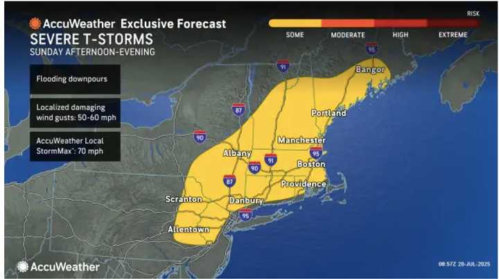
The main event arrives Sunday, July 20, when a trailing cold front collides with the steamy air mass.
Scattered thunderstorms are expected to fire after 2 p.m. Sunday, and intensify toward dusk.
“The latter round of storms could present a risk for severe weather, primarily damaging wind gusts in excess of 58 mph,” the Weather Service said in a briefing.
A few of the heavier cells may also dump torrential rain in short bursts, briefly reducing visibility on busy getaway routes along the I-95 corridor.
While hail and isolated power outages can’t be ruled out, meteorologists stress that the severe threat will be hit-or-miss rather than widespread.
Still, they urge residents to keep mobile alerts enabled and be ready to move indoors quickly. “When thunder roars, go indoors,” the agency reminds.
Conditions become pleasant on Monday, July 21, with mostly sunny skies, light northwest breezes and seasonable highs in the low 80s — ideal for drying out lawns and commutes alike.
Check back to Daily Voice for updates.