Now Packing 160 MPH Winds, Monster Hurricane Erin Elevated To Category 5 Storm
Once a powerful storm, Hurricane Erin has become a record-breaking force, ripping over the Atlantic with sustained winds of 160 mph and achieving the uncommon Category 5 designation.
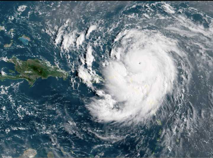
Hurricane Erin as seen from space on Saturday, August 16, at around noon.
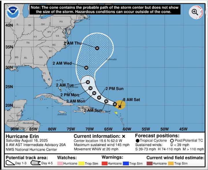
An overview of Erin’s anticipated trajectory through Friday, August 22.
An analysis of the regions that Eric predicts will have the highest steering winds from Sunday, August 17 through Tuesday, August 19.
Erin’s explosive intensification was confirmed by the National Hurricane Center shortly before noon on Saturday, August 16.
It became the first hurricane of the 2025 Atlantic season just 24 hours later, and now it is the strongest storm on the Saffir-Simpson Hurricane Wind Scale.
Meteorologists said nearly perfect atmospheric conditions and exceptionally warm ocean waters contributed to the storm’s quick intensification.
The outer bands of the storm are already pelting the area with tropical storm-force gusts and heavy rain, but Erin’s strongest winds are predicted to stay north of Puerto Rico and the northern Leeward Islands.
Through Sunday, there is a risk of urban flooding, landslides, and flash flooding, particularly in Puerto Rico and the Virgin Islands.
The Southeast Bahamas and the Turks and Caicos Islands may also see tropical storm force winds.
According to forecasters, Erin will likely avoid the US mainland as it continues to track west before veering north and then northeast.
However, the storm’s effects will be felt well beyond its center due to its enormous size and strength.
Over the course of the upcoming week, AccuWeather predicts dangerous surf, potentially fatal rip currents, and coastal flooding over the entire US East Coast, from Florida to New England, as well as the Bahamas and Atlantic Canada.
According to AccuWeather Lead Hurricane Expert Alex DaSilva, residents of the East Coast, from the Carolinas to New England and Atlantic Canada, as well as Bermuda, should keep a careful eye on forecast updates during the following week.
Even a far-off cyclone can cause dangerous conditions along the shore, so locals and visitors are advised to remain vigilant and follow updates.
For updates, return to Daily Voice.