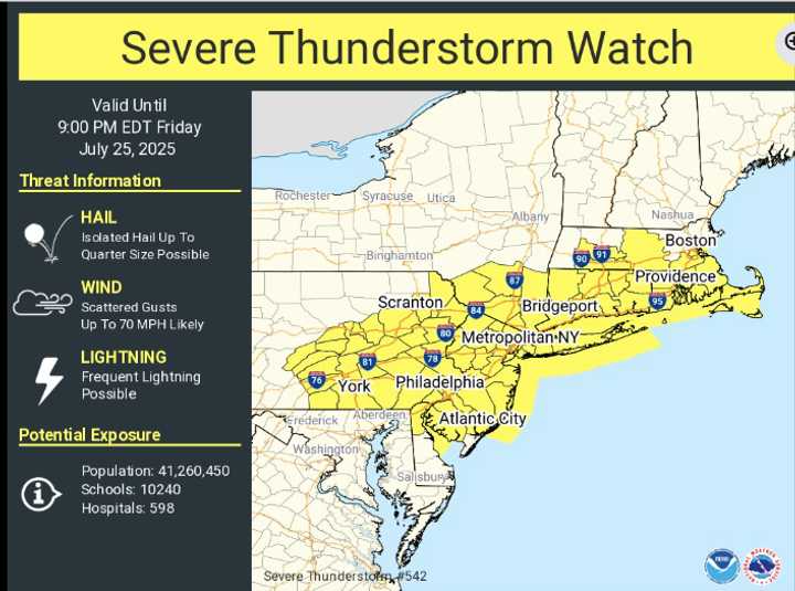
Severe Thunderstorm Watch Issued Issued For These NY Counties
Much of the Northeast is under a Severe Thunderstorm Watch as a powerful system continues to move across the area.
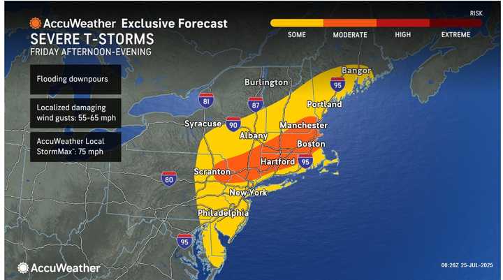
The Severe Thunderstorm Watch is in effect until 9 p.m. on Friday, July 25 for the locations shown in yellow.
It is in force until 9 p.m., having begun at 1:45 p.m. on Friday, July 25.
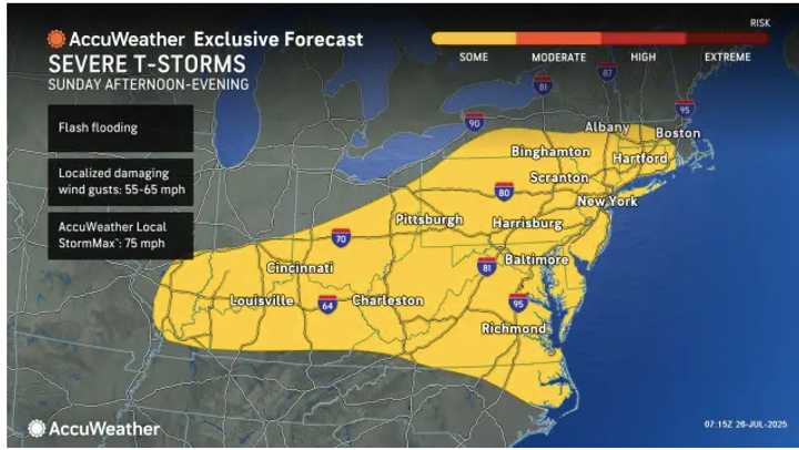
Along with heavy rains that could result in isolated flash flooding, damaging wind gusts of up to 65 mph are expected.
According to the Nationla Weather Service, “these storms are expected to grow in coverage and move across the area through this evening,” “The main threat is from damaging wind gusts, but hail and frequent lightning possible.”
The following counties are under the watch:
New York
- Bronx
- Dutchess
- Kings
- Nassau
- New York (Manhattan)
- Orange
- Putnam
- Queens
- Richmond
- Rockland
- Suffolk
- Sullivan
- Ulster
- Westchester
New Jersey
- Atlantic
- Bergen
- Burlington
- Camden
- Cumberland
- Essex
- Gloucester
- Hudson
- Hunterdon
- Mercer
- Middlesex
- Monmouth
- Morris
- Ocean
- Passaic
- Salem
- Somerset
- Sussex
- Union
- Warren
The state of Connecticut
- Fairfield
- Hartford
- Litchfield
- Middlesex
- New Haven
- New London
- Tolland
- Windham
Pennsylvania
- Adams
- Berks
- Bucks
- Carbon
- Chester
- Columbia
- Cumberland
- Dauphin
- Delaware
- Juniata
- Lackawanna
- Lancaster
- Lebanon
- Lehigh
- Luzerne
- Mifflin
- Monroe
- Montgomery
- Montour
- Northampton
- Northumberland
- Perry
- Philadelphia
- Pike
- Schuylkill
- Snyder
- Union
- Wayne
- York
The state of Massachusetts
- Barnstable
- Bristol
- Dukes
- Hampden
- Hampshire
- Nantucket
- Norfolk
- Plymouth
- Suffolk
- Worcester
For updates, return to Daily Voice.
-
Previous article: The Timing of Severe Storms With Flooding Downpours and Damaged Winds
Previous article: The Timing of Severe Storms With Flooding Downpours and Damaged Winds